

Get your local forecasts, weather articles, and video forecasts from the Texas Storm Chasers, along with interactive weather radar in TSC's Mobile App.
Joined March 2009
- Tweets 111,811
- Following 82,135
- Followers 335,600
- Likes 12,269

11/8 815PM: Emergency crews in Polk County, Texas — that’s in East Texas — are urging evacuations after the Carter Lake Dam near Camden was reported compromised.
If you’re south of the dam (Henry Darden Rd, Marie Rd, Community Dr, Bo Peep, Herb Collins Rd, Girard), leave now and stay clear until officials give the all-clear. Follow Polk County Emergency Management for updates.


Critical fire danger Sunday across Central, South & Southeast Texas. 🔥
Low humidity + strong winds = fast-spreading fires. Avoid outdoor burning & anything that sparks.
#TXwx #FireWeather #Texas #WildfireRisk #BurnBan

Take a look at this morning's satellite loop! Witness the low-level stratus and fog gradually clearing away across the Brazos Valley, Southeast Texas, and near the Texas Gulf Coast. Beautiful morning skies in motion! #TXwx

The blue colors indicate air temperatures at or below freezing Monday morning. Cover those plants if that includes you! Wind chills will feel even colder.

High Wind Warning is in effect from Saturday evening through Sunday afternoon for the Guadalupe Pass, Carlsbad Caverns, and Delaware Mountains.
Sustained winds 35–45 mph, gusts up to 65 mph. Travel will be difficult for high-profile vehicles, and loose objects may be blown around. Avoid mountain routes if possible.


Fairly hot, then turning fairly cold in parts of Texas following a mostly dry cold front passage. Details: piped.video/0A1W-zKHDT4
Texas Storm Chasers ⚡ retweeted

This is 610 N Loop 👀 FOGG
@abc13houston @TxDOT
@TxStormChasers @JenReynaTV
#houwx #htx #TXWX #hounews

It's a lovely day here in Houston, and what a beautiful day across Texas! Badly-in-Chief David Reimer is at the Disasters Expo USA—it's always wonderful to reconnect with new learning opportunities and build partnerships.


Temps in Texas will have their ups and downs this time of year. A strong cold front will bring temps sharply back down this weekend, but how long will the cooldown last? Watch: TexasWeatherRoundup.video/
A Severe Thunderstorm Warning is in effect for southeastern Cameron County, including Brownsville, Los Fresnos, Rancho Viejo, and Port of Brownsville, until 11:15 PM.
At 10:27 PM, radar detected a strong storm moving south at 30 MPH, producing golf ball size hail and winds up to 60 MPH. Expect hail damage to roofs, windows, and vehicles — and wind damage to trees and power lines.
If you’re in the warned area, move indoors immediately and stay away from windows until the storm passes.

Texas Storm Chasers ⚡ retweeted
View of coastal storms from Angleton Texas
@abc13houston
@TxStormChasers @Jeff_Piotrowski @spann
#houwx #htx #TXWX #hounews

Bay City!
Severe Warn Storm @NWSHouston * Until 700 PM CDT.
* At 623 PM CDT, a severe thunderstorm was located over Markham, or 7 miles west of Bay City, moving southeast at 20 mph.
@abc13houston
@TxStormChasers
#houwx #htx #TXWX #hounews
Texas Storm Chasers ⚡ retweeted

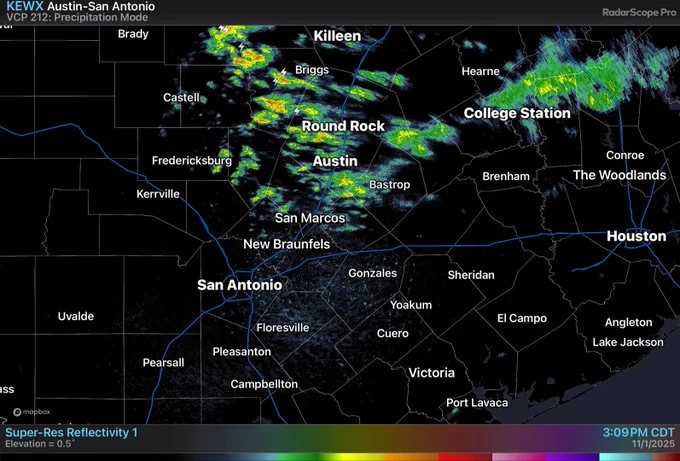
5 PM: More uptick in coverage of shower and storm activity now for areas along and east of the I-10/I-37 corridor, including from the Boerne to San Antonio to New Braunfels region with lightning, locally heavier rainfall rates, and perhaps small hail in the strongest cores. #txwx
Daylight Savings Time ENDS TONIGHT! Clocks will turn back one hour jumping from 2 AM to 1 AM. An hour of extra sleep will be unlocked. BUT this means the sunset will occur before 6 PM tomorrow in #Texas!

Texas Storm Chasers ⚡ retweeted
12:30 PM: Light to moderate rain is moving east-southeast from Llano through Burnet into Williamson counties. An occasional rumble of thunder could be possible. Additional showers and a storm or two becomes possible along/east of the I-10/37 corridor through this afternoon. #txwx

Happy Saturday! This afternoon and evening, there is an increased risk of hail storms across the Coastal Plains, Coastal Bend, and Rio Grande Valley due to a southward-moving cold front. Storm chances will diminish as the front pushes the storms into the Gulf tonight. The best time for storms is between 3 PM and midnight, and tornadoes are unlikely. ~David #TXwx

Happy November, holiday season is upon us. With that comes longer nights. Here is how much daylight we lose throughout #Texas by the end of the month.

Halloween Forecast! Here is a NOT scary Texas Weather Roundup from TSC’s David Reimer: TexasWeatherRoundup.video/
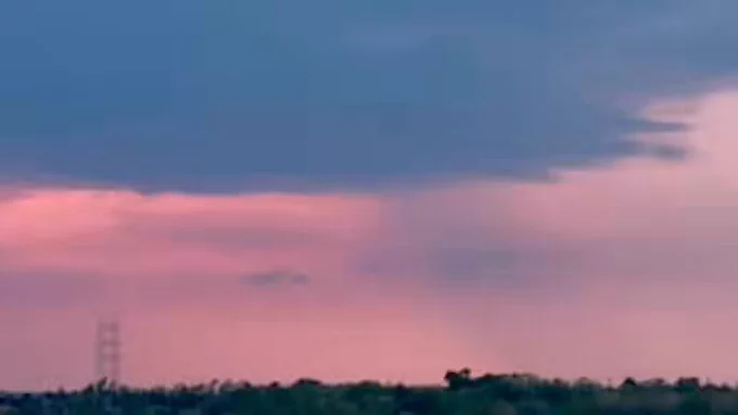
Kingwood!
Shelf Cloud over Kingwood Texas
@abc13houston @MayraABC13
@TxStormChasers
#houwx #htx #TXWX #hounews
