Dantesco retweeted

Así fue nuestra charla virtual análisis de la percepción de la seguridad, un enfoque geográfico a la toma de decisiones en proyectos de impacto social y de los negocios, impulsada por @ProArteLeon
#maps #mapas #geografia #geography #GIS #geomarketing #datascience #datamining

ハクメス3世 retweeted

‘
おはようございます!!
【難易度:★★★☆☆】
さて問題です。
これは何の支出でしょうか?
<選択肢>
① 外壁・塀等工事費
② 植木・庭手入れ代
③ 火災・地震保険料
正解は本日17時
今日も楽しい一日を!
★ファミマビジョンで出題中★
gate-one.co.jp/news/info/832…
#統計 #クイズ #地理 #GIS

Satoru Matsumoto(110100) retweeted

🌊 The Caribbean Basin in stunning relief—where tectonic plates collide, trenches plunge to abyssal depths, and island chains trace the boundaries between worlds.
Beautiful cartography from the 1967 Pergamon World Atlas.
#VintageMaps🗺
#GIS🌐

Notre Dame Geography retweeted

🔊#JourneySticks are an ancient geographical information system #GIS used for millennia.
Glimpses of a brilliant KS1 Y1 lesson 'Making a map of our route' by @OakNational stepping 'old' #GIS and 'new' #GIS + @AphexTwin
#30DayMapChallenge Day 9: Analog
tinyurl.com/35y5wf5r


#30DayMapChallenge
Day8 Urban
Londres, l’une des métropoles les plus dynamiques du monde. Cette carte, à travers un style noir et argenté, révèle la texture urbaine de la capitale britannique (les quartiers denses, les espaces ouverts et le tracé fluide de Tamise).
#GIS #DataViz


🛰️ Map Source: MySpace Tech INT'L | ArcGIS Pro
#GIS #Urbanization #SpatialAnalysis #EkitiState #ArcGISPro
🛰️ Map Source: MySpace Tech INT'L | ArcGIS Pro
#GIS #Urbanization #SpatialAnalysis #EkitiState #ArcGISPro


#30DayMapChallenge
Day7 Accessibility
Et si on prenez les cartes pour voir le temps moyen d’accès aux terminus de bus? Certainement nos utilisons majoritairement les taxis clando pour rejoindre les grandes artères ou gare routières.
#GIS #DataViz

🏙️ Day 8 – Urban | #30DayMapChallenge
Mapped the population density of Western Nigeria, showing how cities like Lagos and Ibadan form dense urban hubs amid rural surroundings. 🌆📊
#GIS #Mapping #UrbanPlanning #DataViz #Nigeria #Cartography


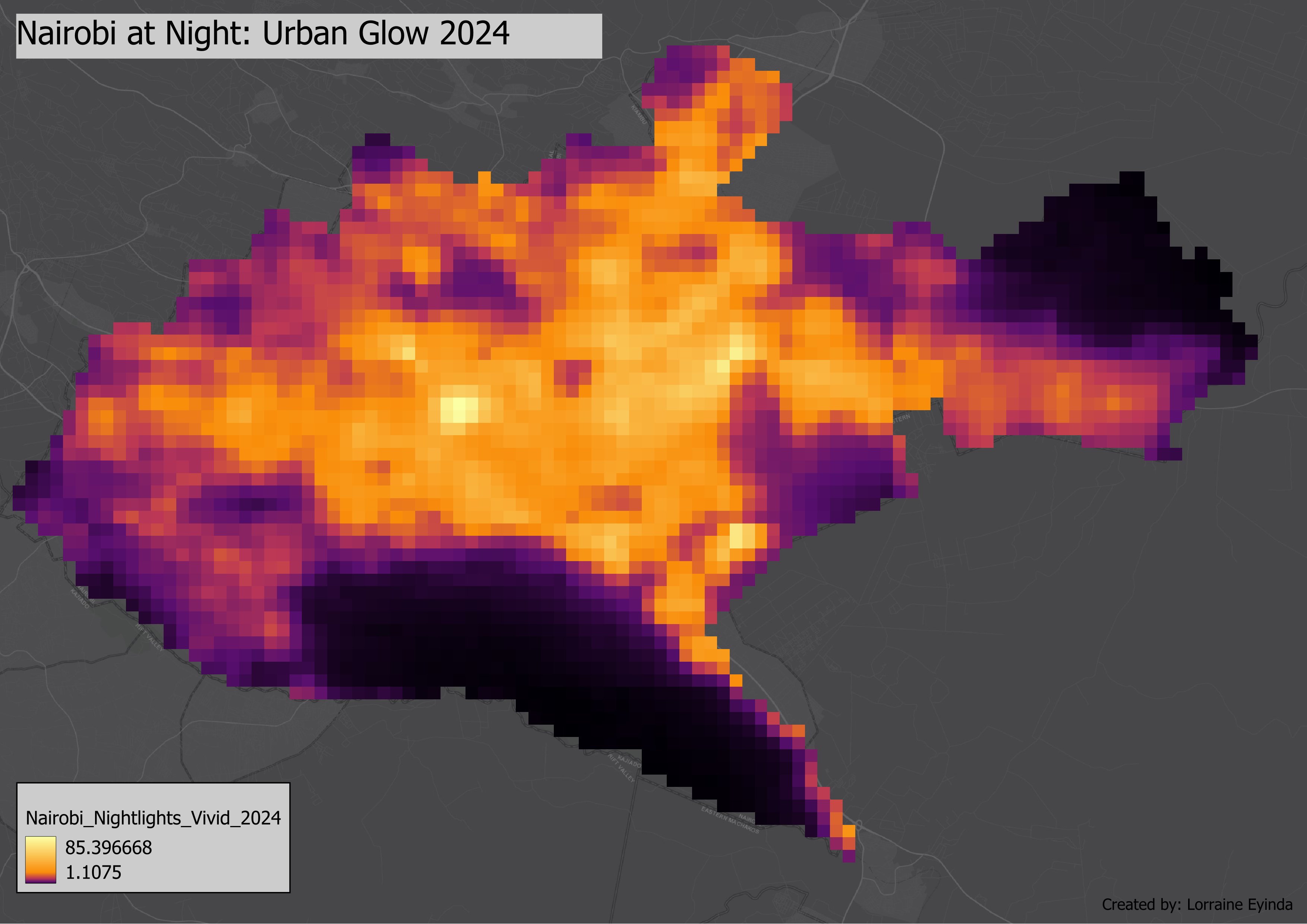
🌃#30DayMapChallenge Day 8 – Urban
Urban Night Lights of Nairobi, Kenya 🇰🇪
Data: NOAA VIIRS 2024 | Tools: GEE & QGIS
#GIS #QGIS #Geospatial #Kenya #NightLights #WorldUrbanismDay
Richard Crawford retweeted

My new map visualizes where people live across Nigeria, from Lagos to Kano, from the river plains to the northern highlands.
Save it, share it, and tell me: which country’s population should I map next?
#cartography #gis #rstats #population #dataviz #geography #ghsl #terrain #rayshader #spatialanalysis #remotesensing #mapdesign #openscience #milosmakesmaps

Imtiaj Iqbal Mahfuj retweeted
When your work shows up in someone else’s map, you feel the spark twice, once in making, and once in witnessing.
Huge thanks to Janhavi for the mention and for this beautiful #30DayMapChallenge piece.
#GIS #Cartography #Mapping #DataViz #30DayMapChallenge


